Fichièr:Riparian strip.jpg
Pas de resolucion mai nauta de disponibla.
Riparian_strip.jpg (655 × 441 pixèl, talha del fichièr: 59 Ko, tipe MIME: image/jpeg)
| Aqueste fichièr proven de Wikimedia Commons?. Las informacions que lo concernisson son afichadas çaijós (procedura). |
| Posició de l'objecte | | Aquesta i altres imatges properes a: OpenStreetMap |
|---|
| Descripcion |
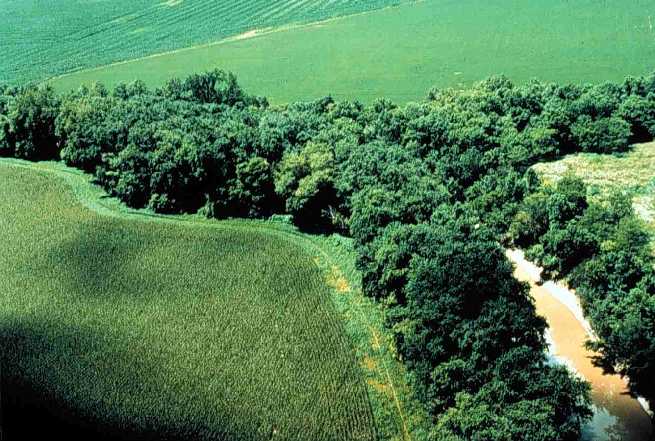
English: Riparian strip on a Lake Erie tributary. Location is the northeastern corner of Van Buren Township, Putnam County, Ohio, United States, east of the village of Belmore; this is the confluence of Yellow Creek and a tiny unnamed run. |
|||
| Data | Data desconeguda | |||
| Font | [1] (context) | |||
| Autor | U.S. Department of Agriculture | |||
| Permission (Reütilizacion d'aqueste fichièr) |
|

![[1]](https://web.archive.org/web/20051220220554/http://www.oh.nrcs.usda.gov/programs/Lake_Erie_Buffer/images/riparian_putnam_co.jpg)
Istoric del fichièr
Clicar sus una data e una ora per veire lo fichièr tal coma èra a aqueste moment
| Data e ora | Miniatura | Dimensions | Utilizaire | Comentari | |
|---|---|---|---|---|---|
| actual | 28 julhet de 2005 a 22.29 | | 655×441 (59 Ko) | Duk | Riparian strip, Putnam County, Ohio, Lake Erie tributary. {{PD-USGov-USDA}} source: http://www.oh.nrcs.usda.gov/programs/Lake_Erie_Buffer/images/riparian_putnam_co.jpg en:Riparian strips |
Paginas que contenon lo fichièr
La pagina çaijós compòrta aqueste imatge :
Usatge global del fichièr
Los autres wikis seguents utilizan aqueste imatge :
- Utilizacion sus an.wikipedia.org
- Utilizacion sus ar.wikipedia.org
- Utilizacion sus be.wikipedia.org
- Utilizacion sus bn.wikipedia.org
- Utilizacion sus bs.wikipedia.org
- Utilizacion sus ca.wikipedia.org
- Utilizacion sus cs.wikipedia.org
- Utilizacion sus cy.wikipedia.org
- Utilizacion sus en.wikipedia.org
- Utilizacion sus en.wiktionary.org
- Utilizacion sus eo.wikipedia.org
- Utilizacion sus es.wikipedia.org
- Utilizacion sus eu.wikipedia.org
- Utilizacion sus fa.wikipedia.org
- Utilizacion sus fi.wikipedia.org
- Utilizacion sus fr.wikipedia.org
- Utilizacion sus gl.wikipedia.org
- Utilizacion sus id.wikipedia.org
- Utilizacion sus it.wikipedia.org
- Utilizacion sus ja.wikipedia.org
- Utilizacion sus ka.wikipedia.org
- Utilizacion sus ko.wikipedia.org
- Utilizacion sus nl.wikipedia.org
- Utilizacion sus pt.wikipedia.org
- Utilizacion sus ru.wikipedia.org
- Utilizacion sus sh.wikipedia.org
- Utilizacion sus sv.wikipedia.org
- Utilizacion sus tt.wikipedia.org
- Utilizacion sus uk.wikipedia.org
- Utilizacion sus www.wikidata.org
Veire l'utilizacion globala d'aqueste fichièr.