Fichièr:Map of Allier Department (France) with NumberedElectoralDistrictsAndCantons2015.png

Talha d'aquesta previsualizacion: 800 × 586 pixèls. Autras resolucions : 320 × 234 pixèls | 640 × 468 pixèls | 1 000 × 732 pixèls.
Fichièr d'origina (1 000 × 732 pixèl, talha del fichièr: 67 Ko, tipe MIME: image/png)
| Aqueste fichièr proven de Wikimedia Commons?. Las informacions que lo concernisson son afichadas çaijós (procedura). |
_with_NumberedElectoralDistrictsAndCantons2015.png?uselang=oc)
Descripcion
| Descripcion |
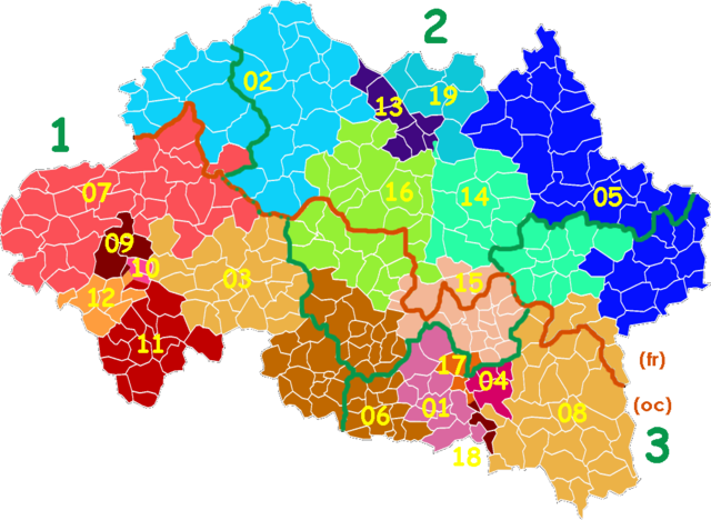
Occitan : Carta del departament d'Alèir amb las circonscripcions legislativas, los cantons e las comunas en 2015 |
| Data | |
| Font | Trabalh personal |
| Autor | Jfblanc |
Publicat jos licéncia(s)
Ieu, autor d'aquesta òbra, publiqui jos la licéncia seguenta:
Ce fichier est sous la licence Creative Commons Attribution – Partage dans les Mêmes Conditions 4.0 International.
- Sètz liure :
- de partejar – de copiar, distribuir e transmetre aquesta òbra
- d'adaptar – d'adaptar aquesta òbra
- Jos las condicions seguentas :
- atribucion – Vos cal atribuir aquesta òbra amb lo biais especificat per l'autor o lo concedent (mas pas dins un sens que suggerís que vos apròvan o qu'apròvan l'utilizacion d'aquesta òbra).
- partiment a l'identic – Se modificatz, transformatz, o vos basatz sus aquesta òbra, vos cal distribuir l'òbra resultanta jos la meteissa licéncia o una licéncia similara a aquesta.
Istoric del fichièr
Clicar sus una data e una ora per veire lo fichièr tal coma èra a aqueste moment
| Data e ora | Miniatura | Dimensions | Utilizaire | Comentari | |
|---|---|---|---|---|---|
| actual | 1 novembre de 2014 a 20.50 | | 1 000×732 (67 Ko) | Jfblanc | Green: Number of Electoral District for French National Assembly Yellow: Number of Canton for 2015 Departemental Election oc/fr: Occitan-French lingustic boundary |
| 1 novembre de 2014 a 20.34 |  | 1 000×732 (271 Ko) | Jfblanc | User created page with UploadWizard |
Paginas que contenon lo fichièr
Las paginas çaijós compòrtan aqueste imatge :
Usatge global del fichièr
Los autres wikis seguents utilizan aqueste imatge :
- Utilizacion sus nl.wikipedia.org
_with_NumberedElectoralDistrictsAndCantons2015.png)