Fichièr:Map Cymru 1996 gyda rhifau.svg

Talha d'aquesta previsualizacion PNG per aquest fichièr SVG: 483 × 600 pixèls. Autras resolucions : 193 × 240 pixèls | 386 × 480 pixèls | 618 × 768 pixèls | 824 × 1 024 pixèls | 1 649 × 2 048 pixèls | 500 × 621 pixèls.
Fichièr d'origina (Fichièr SVG, resolucion de 500 × 621 pixèls, talha : 50 Ko)
| Aqueste fichièr proven de Wikimedia Commons?. Las informacions que lo concernisson son afichadas çaijós (procedura). |
Descripcion
This version has all the extra SVG-cruft removed, all counties in separate groups, and the "id" field of each group set to the Welsh name of each county rather than a number.
| Descripcion | Same as Image:Map Cymru 1996 heb enwau.svg, but the numbers from Image:WalesNumbered.png have been added back. |
| Font | Image:WalesNumbered.png + GIMP + VectorMagic + Inkscape + emacs |
| Autor | User:Marnanel, after en:User:Morwen |
| Permission (Reütilizacion d'aqueste fichièr) |
GFDL |
| Autras versions | Image:WalesNumbered.png |
Publicat jos licéncia(s)
| Aqueste fichièr es jos licéncia Creative Commons licéncia generica atribucion-partiment a l'identic 3.0 Subjecte a l'avís legal. | ||
| ||
| Aquest avís de llicència s'ha afegit a aquest fitxer d'acord amb l'actualització de la llicència GFDL. |

|
Avètz la permission de copiar, distribuir e modificar aqueste document segon los tèrmes de la Licéncia de documentacion liura GNU, version 1.2 o mai recenta publicada per la Free Software Foundation; sens seccions inalterablas, sens tèxte de primièra pagina de tempa e sens tèxte de darrièra pagina de tempa. Un exemplar de la licéncia es inclús dins la seccion intitulada GNU Free Documentation License. Subjecte a l'avís legal. |
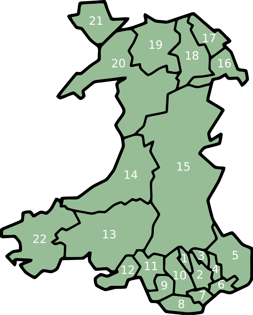
key
- Merthyr Tydfil/Merthyr Tudful
- Caerphilly/Caerffili
- Blaenau Gwent
- Torfaen/Tor-faen
- Monmouthshire/Sir Fynwy
- Newport/Casnewydd
- Cardiff/Caerdydd
- Vale of Glamorgan/Bro Morgannwg
- Bridgend/Pen-y-bont ar Ogwr
- Rhondda Cynon Taff/Rhondda Cynon Tâf
- Neath Port Talbot/Castell-nedd Port Talbot
- Swansea/Abertawe
- Carmarthenshire/Sir Gaerfyrddin
- Ceredigion
- Powys
- Wrexham/Wrecsam
- Flintshire/Sir y Fflint
- Denbighshire/Sir Ddinbych
- Conwy
- Gwynedd
- Isle of Anglesey/Ynys Môn
- Pembrokeshire/Sir Benfro
Istoric del fichièr
Clicar sus una data e una ora per veire lo fichièr tal coma èra a aqueste moment
| Data e ora | Miniatura | Dimensions | Utilizaire | Comentari | |
|---|---|---|---|---|---|
| actual | 12 febrièr de 2008 a 02.06 | | 500×621 (50 Ko) | Marnanel | This version has all the extra SVG-cruft removed, all counties in separate groups, and the "id" field of each group set to the Welsh name of each county rather than a number. {{Information |Description=Same as Image:Map Cymru 1996 heb enwau.svg, but |
Paginas que contenon lo fichièr
Las paginas çaijós compòrtan aqueste imatge :
Usatge global del fichièr
Los autres wikis seguents utilizan aqueste imatge :
- Utilizacion sus br.wikipedia.org
- Utilizacion sus el.wikipedia.org
- Utilizacion sus en.wikipedia.org
- Utilizacion sus eu.wikipedia.org
- Britainia Handia
- Gales
- Cardiff
- Llanfairpwllgwyngyll
- Swansea
- Gwynedd
- Denbighshire
- Ynys Môn
- Carmarthenshire
- Ceredigion
- Newport (Gales)
- Merthyr Tydfil
- Vale of Glamorgan
- Blaenau Gwent
- Torfaen
- Monmouthshire
- Pembrokeshire
- Conwy
- Flintshire
- Wrecsam
- Bridgend
- Rhondda Cynon Taf
- Castell-nedd Port Talbot
- Powys
- Portmeirion
- Blaenau Ffestiniog
- Pwllheli
- Txantiloi:Galesko eskualde aurkibidea
- Galesko azpibanaketak
- Bangor (Gales)
- Cricieth
- Harlech
- Llanbedr
- Aberangell
- Aberdesach
- Aberdyfi
- Abererch
- Abergeirw
- Abergwyngregyn
- Abergynolwyn
- Aberllefenni
- Abersoch
- Abertrinant
- Afon Wen
- Arthog
- Bala (Gales)
Veire l'utilizacion globala d'aqueste fichièr.