Fichièr:West Asia Köppen Map.png
Talha d'aquesta previsualizacion: 502 × 599 pixèls. Autras resolucions : 201 × 240 pixèls | 402 × 480 pixèls | 990 × 1 182 pixèls.
Fichièr d'origina (990 × 1 182 pixèl, talha del fichièr: 511 Ko, tipe MIME: image/png)
| Aqueste fichièr proven de Wikimedia Commons?. Las informacions que lo concernisson son afichadas çaijós (procedura). |
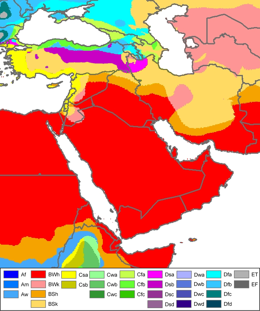
| Peel, M. C. and Finlayson, B. L. and McMahon, T. A. (2007). "Updated world map of the Köppen-Geiger climate classification". Hydrol. Earth Syst. Sci. 11: 1633-1644. ISSN 1027-5606. |
Legend
Descripcion
| Descripcion | Climate map of (South)west-Asia and adjacent areas (from the "Updated world map of the Köppen-Geiger climate classification"). |
| Data | |
| Font | Hydrology and Earth System Sciences: "Updated world map of the Köppen-Geiger climate classification" (Supplement) - Original file was a JPG-file, this file is has been converted to a PNG-file, without extra modifications, by me (Jeroen). |
| Autor |
Peel, M. C., Finlayson, B. L., and McMahon, T. A. (University of Melbourne) |
| Permission (Reütilizacion d'aqueste fichièr) |

|
Aquesta imatge (de tipus meteorology) s'hauria de tornar a crear utilitzant gràfics vectorials com ara un fitxer SVG. Això té diversos avantatges; en trobareu més informació a Commons:Media for cleanup. Si ja disposeu d'una versió d'aquesta imatge en format SVG, us preguem que la pengeu; després, reemplaceu aquesta plantilla amb la plantilla {{Vector version available|nom nou de la imatge.svg}} en aquesta imatge.
|
Related maps
User Jeroenvrp made for these continents and areas a cropped and resized version:
- Africa Köppen Map.png
- Asia Köppen Map.png
- Australia-Oceania Köppen Map.png
- Europe Köppen Map.png
- North America Köppen Map.png
- Russia Köppen Map.png
- South America Köppen Map.png
- West Asia Köppen Map.png.
User LordToran made from the same data these maps:
- Klimagürtel-der-erde-eisklima.png
- Klimagürtel-der-erde-gemäßigte-zone.png
- Klimagürtel-der-erde-polargebiete.png
- Klimagürtel-der-erde-subtropen.png
- Klimagürtel-der-erde-tropen.png
- Klimagürtel-der-erde-tundra.png
- Klimagürtel-der-erde-warmgemäßigte-zone.png
- Klimagürtel-der-erde.png
- Klimagürtel-der-erde.svg
- Klimate-humidität.png
- Köppen-geiger-hessd-2007.svg
- Köppen-vereinfacht.svg
- Trockenklimate.png
Publicat jos licéncia(s)
Aqueste fichièr es jos licéncia Creative Commons licéncia generica atribucion-partiment a l'identic 3.0
- Sètz liure :
- de partejar – de copiar, distribuir e transmetre aquesta òbra
- d'adaptar – d'adaptar aquesta òbra
- Jos las condicions seguentas :
- atribucion – Vos cal atribuir aquesta òbra amb lo biais especificat per l'autor o lo concedent (mas pas dins un sens que suggerís que vos apròvan o qu'apròvan l'utilizacion d'aquesta òbra).
- partiment a l'identic – Se modificatz, transformatz, o vos basatz sus aquesta òbra, vos cal distribuir l'òbra resultanta jos la meteissa licéncia o una licéncia similara a aquesta.
Istoric del fichièr
Clicar sus una data e una ora per veire lo fichièr tal coma èra a aqueste moment
| Data e ora | Miniatura | Dimensions | Utilizaire | Comentari | |
|---|---|---|---|---|---|
| actual | 21 novembre de 2016 a 12.57 | | 990×1 182 (511 Ko) | Pandakekok9 | Transparent |
| 13 març de 2011 a 12.23 |  | 990×1 182 (543 Ko) | Maphobbyist | Painted the Caspian Sea as white as it should have been, because the Köppen system is based on the concept that climate types are correlated with the natural vegetation. Thus with Köppen, climate zone boundaries have been selected with vegetation distri | |
| 12 octobre de 2007 a 23.01 |  | 990×1 182 (507 Ko) | Jeroen | Citation: '''Peel, M. C., Finlayson, B. L., and McMahon, T. A.: Updated world map of the Köppen-Geiger climate classification, Hydrol. Earth Syst. Sci., 11, 1633-1644, 2007.''' {{Information |Description= Climate map of North-America (from the "[[:Ima |
Paginas que contenon lo fichièr
La pagina çaijós compòrta aqueste imatge :
Usatge global del fichièr
Los autres wikis seguents utilizan aqueste imatge :
- Utilizacion sus af.wikipedia.org
- Utilizacion sus ar.wikipedia.org
- Utilizacion sus de.wikipedia.org
- Utilizacion sus en.wikipedia.org
- Utilizacion sus eo.wikipedia.org
- Utilizacion sus es.wikipedia.org
- Utilizacion sus es.wikibooks.org
- Utilizacion sus eu.wikipedia.org
- Utilizacion sus fy.wikipedia.org
- Utilizacion sus ha.wikipedia.org
- Utilizacion sus hy.wikipedia.org
- Utilizacion sus it.wikipedia.org
- Utilizacion sus ja.wikipedia.org
- Utilizacion sus ja.wikibooks.org
- Utilizacion sus nl.wikipedia.org
- Utilizacion sus nn.wikipedia.org
- Utilizacion sus ro.wikipedia.org
- Utilizacion sus sl.wikipedia.org
- Utilizacion sus sr.wikipedia.org
- Utilizacion sus te.wikipedia.org
- Utilizacion sus th.wikipedia.org
- Utilizacion sus uk.wikipedia.org
- Utilizacion sus vi.wikipedia.org