Fichièr:Satellite image of Flevopolder, Netherlands (5.48E 52.43N).png

Talha d'aquesta previsualizacion: 800 × 548 pixèls. Autras resolucions : 320 × 219 pixèls | 640 × 439 pixèls | 1 024 × 702 pixèls.
Fichièr d'origina (1 024 × 702 pixèl, talha del fichièr: 1,49 Mo, tipe MIME: image/png)
| Aqueste fichièr proven de Wikimedia Commons?. Las informacions que lo concernisson son afichadas çaijós (procedura). |
.png?uselang=oc)
| Descripcion |
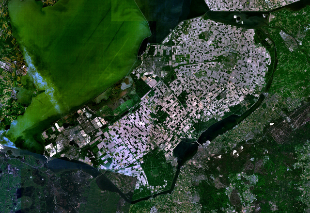
English: Satellite image of the Flevopolder in the Netherlands. Technically, the Flevopolder consists of Zuidelijk Flevoland (Southern Flevoland), Oostelijk Flevoland (Eastern Flevoland) and the Noordoostpolder (North Eastern Polder). This image shows Southern and Eastern Flevoland. |
| Font | Screenshot from NASA's World Wind |
| Autor | Fotografia : NASA |
| Cette image est dans le domaine public car elle est constituée d'une capture d'écran du logiciel World Wind de la NASA qui utilise des données du domaine public, comme Blue Marble, MODIS, Landsat, SRTM, USGS ou GLOBE.
|
 |
Istoric del fichièr
Clicar sus una data e una ora per veire lo fichièr tal coma èra a aqueste moment
| Data e ora | Miniatura | Dimensions | Utilizaire | Comentari | |
|---|---|---|---|---|---|
| actual | 4 mai de 2005 a 13.25 | | 1 024×702 (1,49 Mo) | Galwaygirl | Satellite image of the Flevopolder in the Netherlands. Screenshot from NASA's World Wind {{PD}} |
Paginas que contenon lo fichièr
La pagina çaijós compòrta aqueste imatge :
Usatge global del fichièr
Los autres wikis seguents utilizan aqueste imatge :
- Utilizacion sus an.wikipedia.org
- Utilizacion sus ar.wikipedia.org
- Utilizacion sus ast.wikipedia.org
- Utilizacion sus br.wikipedia.org
- Utilizacion sus ca.wikipedia.org
- Utilizacion sus cs.wikipedia.org
- Utilizacion sus da.wikipedia.org
- Utilizacion sus de.wikipedia.org
- Utilizacion sus el.wikipedia.org
- Utilizacion sus en.wikipedia.org
- Utilizacion sus es.wikipedia.org
- Utilizacion sus eu.wikipedia.org
- Utilizacion sus fa.wikipedia.org
- Utilizacion sus fr.wikipedia.org
- Utilizacion sus gl.wikipedia.org
- Utilizacion sus he.wikipedia.org
- Utilizacion sus hr.wikipedia.org
- Utilizacion sus hy.wikipedia.org
- Utilizacion sus id.wikipedia.org
- Utilizacion sus kk.wikipedia.org
- Utilizacion sus ko.wikipedia.org
- Utilizacion sus ms.wikipedia.org
- Utilizacion sus nl.wikipedia.org
- Utilizacion sus no.wikipedia.org
- Utilizacion sus ro.wikipedia.org
- Utilizacion sus ru.wikipedia.org
- Utilizacion sus sh.wikipedia.org
- Utilizacion sus simple.wikipedia.org
- Utilizacion sus sr.wikipedia.org
Veire l'utilizacion globala d'aqueste fichièr.
.png)
.png)