Fichièr:Sahel Map-Africa rough.png
Talha d'aquesta previsualizacion: 800 × 370 pixèls. Autras resolucions : 320 × 148 pixèls | 640 × 296 pixèls | 1 024 × 474 pixèls | 2 000 × 925 pixèls.
Fichièr d'origina (2 000 × 925 pixèl, talha del fichièr: 291 Ko, tipe MIME: image/png)
| Aqueste fichièr proven de Wikimedia Commons?. Las informacions que lo concernisson son afichadas çaijós (procedura). |

|
This file requires updating because: south soudan In doing so, you could add a timestamp to the file.
|
| Descripcion |
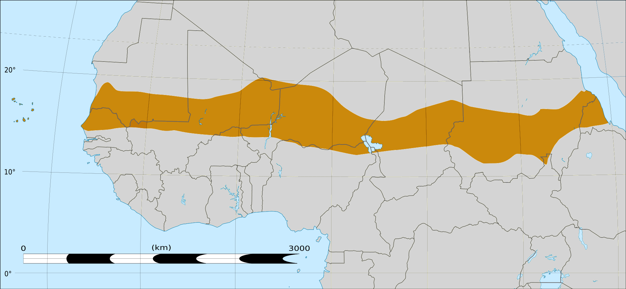
English: Map of Africa, with the Sahel highlighted in orange.
This is roughly the African land area between the lines of 200mm (north) and 600mm (south) mean 20th century annual rainfall. This is limited to land areas directly to the south of the Sahara desert and including the islands of Cape Verde, but not including other areas in Africa with the same rainfall statistics. This is one, but not the only, definition of the Sahel region. |
|||
| Data | 20 febrièr de 2009 03:54 (UTC) | |||
| Font |
Felix Koenig: "created/photographed by myself (based on the existing blank map of Africa)"
|
|||
| Autor | ||||
| Autras versions |
|


| Això és una imatge retocada, cosa que vol dir que ha estat alterada digitalment de la seva versió original. Modificacions: Reproduced Sahel boundary from Map sahel.jpg on png map, cropped. L'original es pot veure a: BlankMap-Africa2.png:
|
Publicat jos licéncia(s)
Ieu, autor d'aquesta òbra, publiqui jos las licéncias seguentas:

|
Avètz la permission de copiar, distribuir e modificar aqueste document segon los tèrmes de la Licéncia de documentacion liura GNU, version 1.2 o mai recenta publicada per la Free Software Foundation; sens seccions inalterablas, sens tèxte de primièra pagina de tempa e sens tèxte de darrièra pagina de tempa. Un exemplar de la licéncia es inclús dins la seccion intitulada GNU Free Documentation License. |
This file is licensed under the Creative Commons Attribution-Share Alike 4.0 International, 3.0 Unported, 2.5 Generic, 2.0 Generic and 1.0 Generic license.
- Sètz liure :
- de partejar – de copiar, distribuir e transmetre aquesta òbra
- d'adaptar – d'adaptar aquesta òbra
- Jos las condicions seguentas :
- atribucion – Vos cal atribuir aquesta òbra amb lo biais especificat per l'autor o lo concedent (mas pas dins un sens que suggerís que vos apròvan o qu'apròvan l'utilizacion d'aquesta òbra).
- partiment a l'identic – Se modificatz, transformatz, o vos basatz sus aquesta òbra, vos cal distribuir l'òbra resultanta jos la meteissa licéncia o una licéncia similara a aquesta.
Podètz causir la licéncia que volètz.
|
|
Avètz la permission de copiar, distribuir e modificar aqueste document segon los tèrmes de la Licéncia de documentacion liura GNU, version 1.2 o mai recenta publicada per la Free Software Foundation; sens seccions inalterablas, sens tèxte de primièra pagina de tempa e sens tèxte de darrièra pagina de tempa. Un exemplar de la licéncia es inclús dins la seccion intitulada GNU Free Documentation License. |
Registre original de càrregues
This image is a derivative work of the following images:
- File:Map_sahel.jpg licensed with GFDL
- 2005-05-30T17:36:46Z King 800x800 (89588 Bytes) one moment please
- File:BlankMap-Africa2.png licensed with Cc-by-sa-3.0,2.5,2.0,1.0, GFDL
- 2008-03-08T18:02:20Z Sadalmelik 1754x1546 (51013 Bytes) {{Information |Description=Blank map of Africa |Source=self-made |Date=2008-03-08 |Author= [[User:Sadalmelik|Sadalmelik]] |Permission= |other_versions= }} [[Category:Blank maps of Africa]]
Téléversé avec derivativeFX
Istoric del fichièr
Clicar sus una data e una ora per veire lo fichièr tal coma èra a aqueste moment
| Data e ora | Miniatura | Dimensions | Utilizaire | Comentari | |
|---|---|---|---|---|---|
| actual | 17 març de 2018 a 16.15 | | 2 000×925 (291 Ko) | Maphobbyist | South Sudan border |
| 20 febrièr de 2009 a 04.02 |  | 1 384×658 (29 Ko) | T L Miles | {{Information |Description=*Description: A map of Africa: the Sahel highlighted in orange. Note, this is ROUGHLY the African land area between the lines of 200mm (north) and 600mm (south) mean 20th century annual rainfall. This is limited to land areas d |
Paginas que contenon lo fichièr
La pagina çaijós compòrta aqueste imatge :
Usatge global del fichièr
Los autres wikis seguents utilizan aqueste imatge :
- Utilizacion sus af.wikipedia.org
- Utilizacion sus als.wikipedia.org
- Utilizacion sus ar.wikipedia.org
- Utilizacion sus az.wikipedia.org
- Utilizacion sus bcl.wikipedia.org
- Utilizacion sus be.wikipedia.org
- Utilizacion sus bg.wikipedia.org
- Utilizacion sus bn.wikipedia.org
- Utilizacion sus br.wikipedia.org
- Utilizacion sus ca.wikipedia.org
- Utilizacion sus ce.wikipedia.org
- Utilizacion sus da.wikipedia.org
- Utilizacion sus en.wikipedia.org
- Utilizacion sus eu.wikipedia.org
- Utilizacion sus fa.wikipedia.org
- Utilizacion sus fi.wiktionary.org
- Utilizacion sus fr.wikipedia.org
- Utilizacion sus fr.wikinews.org
- Utilizacion sus ha.wikipedia.org
- Utilizacion sus ig.wikipedia.org
- Utilizacion sus incubator.wikimedia.org
- Utilizacion sus it.wikipedia.org
- Utilizacion sus ja.wikipedia.org
- Utilizacion sus ka.wikipedia.org
- Utilizacion sus ko.wikipedia.org
- Utilizacion sus mg.wikipedia.org
- Utilizacion sus mk.wikipedia.org
Veire l'utilizacion globala d'aqueste fichièr.