Fichièr:Provinces of France.png
Talha d'aquesta previsualizacion: 596 × 599 pixèls. Autras resolucions : 239 × 240 pixèls | 477 × 480 pixèls | 894 × 899 pixèls.
Fichièr d'origina (894 × 899 pixèl, talha del fichièr: 39 Ko, tipe MIME: image/png)
| Aqueste fichièr proven de Wikimedia Commons?. Las informacions que lo concernisson son afichadas çaijós (procedura). |

|
Una version vectoriala d'aqueste imatge existís, dins lo format "SVG".
Deuriá èsser utilizada a la plaça de la presenta version per d'afichatges en dimensions mai grandas o que necessitan una resolucion melhora. File:Provinces of France.png → File:Provinces of France (numered-monochrome).svg
Per mai d'entresenhas suls imatges vectorials, consultatz la pagina de transicion de Commons cap al format SVG. Vejatz tanben las entresenhas a prepaus del biais que lo logicial MediaWiki supòrta los imatges al format SVG. |
.svg) |
Descripcion
Español: Provincias de Francia
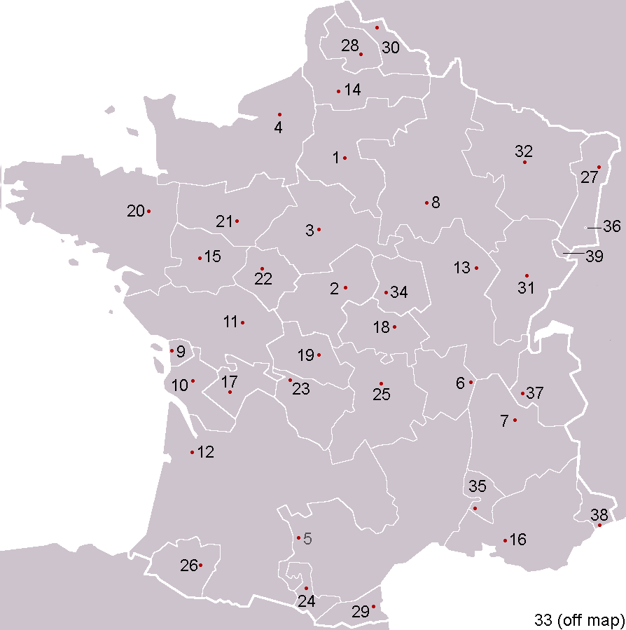
Pre-Republican provinces of France, numbered according to union with France, with provincial capitals marked.
Created by reference to a 1952 Nouveau Petit Larousse by User:OwenBlacker and licenced under the GFDL.
Provinces as follows, in the format English name (French name, Year of union; Capital):
- Royal Domain (Île-de-France, 987, Paris)
- Berry (Berry, 1101, Bourges)
- Duchy of Orléanais (Orléanais, 1198, Orléans)
- Normandy (Normandie, 1204, Rouen)
- Languedoc, mainly the County of Toulouse (Languedoc, 1270, Toulouse)
- Lyonnais (Lyonnais, 1313, Lyon)
- Dauphiné, (Dauphiné, 1349, Grenoble)
- County of Champagne (Champagne, 1361, Troyes)
- Aunis, a fief of Aquitaine (Aunis, 1371, La Rochelle)
- Saintonge (Saintonge, 1371, Saintes)
- Poitou (Poitou, 1416, Poitiers)
- Duchy of Aquitaine (Aquitaine, 1453, Bordeaux), taken from England and split into provinces of Gascogne (Armagnac) and Guyenne (Bordeaux), but excluding the viscounties of Foix, Béarn, Bigorre and Périgord (kept by Navarre)
- Duchy of Burgundy (Bourgogne, 1477, Dijon)
- Picardy (Picardie, 1482, Amiens)
- Anjou (Anjou, 1482, Angers)
- County of Provence (Provence, 1482, Aix-en-Provence)
- County of Angoulême (Angoumois, 1515, Angoulême)
- Duchy of Bourbon (Bourbonnais, 1527, Moulins)
- La Marche (Marche, 1527, Guéret)
- Duchy of Britanny (Bretagne, 1532, Rennes)
- County of Maine (Maine, 1584, Le Mans) and County of Perche (Perche, 1525, Nogent-le-Rotrou)
- Touraine (Touraine, 1584, Tours)
- Limousin (Limousin, 1589, Limoges), excluding Viscounty of Périgord (kept by Navarre)
- County of Foix (Comté de Foix, 1607, Foix) and Viscounty of Périgord (Périgord, 1607, Périgueux, attached to province of Guyenne), both former fiefs from Navarre
- Duchy of Auvergne (Auvergne, 1610, Clermont-Ferrand)
- Viscounty of Béarn (Béarn, 1620, Pau)
- Alsace (Alsace, 1648, Strasbourg)
- County of Artois, a fief of the w:Habsburgs' Spanish Netherlands (Artois, 1659, Arras)
- Roussillon (Roussillon, 1659, Perpignan)
- Flanders, a fief of the w:Habsburgs' Spanish Netherlands (Flandre, 1668, Lille)
- Free County of Burgundy (Franche-Comté, 1678, Besançon)
- Duchy of Lorraine, a personal territory of Stanisław I of Poland within the Holy Roman Empire (Lorraine, 1766, Nancy)
- Corsica (off map, Corse, 1768, Ajaccio)
The following were not provinces of France before the Revolution, but joined or were annexed to France after it, when departments had replaced all former provinces: - Duchy of Nivernais (Nivernais, 1789, Nevers)
- Comtat Venaissin, a Papal fief (Comtat Venaissain, 1791, Avignon)
- Imperial Free City of Mulhouse (Mulhouse, 1798)
- Duchy of Savoy, a state of the Kingdom of Sardinia-Piedmont (Savoie, 1860, Chambéry)
- County of Nice, a state of the Kingdom of Sardinia-Piedmont (Comté de Nice, 1860, Nice)
- Principality of Montbéliard (Montbéliard, 1816, Montbéliard)
- Free cities of Menton and Roquebrune (1861), joining France after the separation (under the protectorate of Sardinia) in 1848 from Monaco

|
Avètz la permission de copiar, distribuir e modificar aqueste document segon los tèrmes de la Licéncia de documentacion liura GNU, version 1.2 o mai recenta publicada per la Free Software Foundation; sens seccions inalterablas, sens tèxte de primièra pagina de tempa e sens tèxte de darrièra pagina de tempa. Un exemplar de la licéncia es inclús dins la seccion intitulada GNU Free Documentation License. |
| Aqueste fichièr es jos licéncia Creative Commons licéncia generica atribucion-partiment a l'identic 3.0 | ||
| ||
| Aquest avís de llicència s'ha afegit a aquest fitxer d'acord amb l'actualització de la llicència GFDL. |
derivative works
Derivative works of this file: Forteresses marches de Bretagne.png
Istoric del fichièr
Clicar sus una data e una ora per veire lo fichièr tal coma èra a aqueste moment
| Data e ora | Miniatura | Dimensions | Utilizaire | Comentari | |
|---|---|---|---|---|---|
| actual | 5 febrièr de 2005 a 00.53 | | 894×899 (39 Ko) | OwenBlacker | Corrected map |
| 4 febrièr de 2005 a 23.59 |  | 894×899 (39 Ko) | OwenBlacker | Corrected map | |
| 4 febrièr de 2005 a 20.24 |  | 894×899 (39 Ko) | OwenBlacker | Pre-Republican provinces of France |
Paginas que contenon lo fichièr
La pagina çaijós compòrta aqueste imatge :
Usatge global del fichièr
Los autres wikis seguents utilizan aqueste imatge :
- Utilizacion sus an.wikipedia.org
- Utilizacion sus ar.wikipedia.org
- كورسيكا
- لورين (منطقة)
- لانغيدوك
- بروفنس
- غشكونية
- بيكاردي
- ألزس
- إيل دو فرانس
- ليموزان
- أوني
- إفرنش كمته
- منطقة سافوا
- دوفيني
- روسيون (مقاطعة)
- قالب:مقاطعات فرنسية سابقة
- بيرش
- برطانية (فرنسا)
- أنجو
- بواتو
- مين (مقاطعة)
- بونيفاسيو
- شامبانيا (مقاطعة)
- دوقية نرمندية
- دول (فرنسا)
- بروفين
- تيل (فرنسا)
- آجدي
- روآن
- فوجير
- مورلي (فرنسا)
- بوتو (فرنسا)
- آركاشون
- جينيفيلييه
- بريانسون
- كاستيلان
- بيساك
- بنطيز
- أوري (فرنسا)
- كاربينتراس
- درو (فرنسا)
- ألتكيرش
- آنجليه
- أرجينتان
- أوبيناس
- إبلافية
- بريودي
- كابورج
- قشتال
- فورباخ
Veire l'utilizacion globala d'aqueste fichièr.