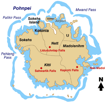
Fichièr:Pohnpei map.gif
Pohnpei_map.gif (366 × 356 pixèl, talha del fichièr: 19 Ko, tipe MIME: image/gif)
Istoric del fichièr
Clicar sus una data e una ora per veire lo fichièr tal coma èra a aqueste moment
| Data e ora | Miniatura | Dimensions | Utilizaire | Comentari | |
|---|---|---|---|---|---|
| actual | 7 abril de 2008 a 19.59 |  | 366×356 (19 Ko) | Scanlan | {{Information |Description=Map of the Island of Pohnpei, in the Federated States of Micronesia |Source=http://www.doi.gov/oia/press/2008/04042008.html |Date=April 4, 2008 |Author= United States government Department of the Interior |Permission= |other |
Paginas que contenon lo fichièr
La pagina çaijós compòrta aqueste imatge :
Usatge global del fichièr
Los autres wikis seguents utilizan aqueste imatge :
- Utilizacion sus ar.wikipedia.org
- Utilizacion sus bo.wikipedia.org
- Utilizacion sus ca.wikipedia.org
- Utilizacion sus cs.wikipedia.org
- Utilizacion sus de.wikipedia.org
- Utilizacion sus en.wikipedia.org
- Utilizacion sus eo.wikipedia.org
- Utilizacion sus es.wikipedia.org
- Utilizacion sus fa.wikipedia.org
- Utilizacion sus fr.wikipedia.org
- Utilizacion sus gl.wikipedia.org
- Utilizacion sus it.wikipedia.org
- Utilizacion sus ja.wikipedia.org
- Utilizacion sus ka.wikipedia.org
- Utilizacion sus ko.wikipedia.org
Veire l'utilizacion globala d'aqueste fichièr.

