Fichièr:Lake Merritt Oakland California panorama.jpg
Pas de resolucion mai nauta de disponibla.
Lake_Merritt_Oakland_California_panorama.jpg (800 × 299 pixèl, talha del fichièr: 27 Ko, tipe MIME: image/jpeg)
| Aqueste fichièr proven de Wikimedia Commons?. Las informacions que lo concernisson son afichadas çaijós (procedura). |
|
Ceci est une photographie d’un monument référencé dans le National Register of Historic Places des États-Unis sous le numéro 66000205. |
| Descripcion |
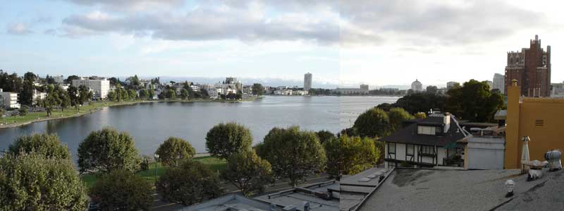
English: Composite of two images taken by Aran Johnson on September 8, 2005 at 18:42 PM local time. Looking west across Lake Merritt. The street visible through the trees in the foreground is Grand Avenue. On the other side of the lake, the road running alongside the curve of the lake is Lakeshore Drive. The low lying building at the far end of the lake just to the right of center, is the Henry J. Kaiser Convention Center. To the right of that, the square building with the peaked roof is the Oakland Court House. The brick building at the far right of the image is the Bellevue-Staten Building a residential high rise dating from the 1920's. |
| Data | |
| Font | Travail personnel de la personne qui a téléchargé à l'origine le document. |
| Autor | Konky2000 |
| Posició de l'objecte | | Aquesta i altres imatges properes a: OpenStreetMap |
|---|
Publicat jos licéncia(s)
Aqueste fichièr es jos licéncia Creative Commons licéncia generica atribucion-partiment a l'identic 2.5
- Sètz liure :
- de partejar – de copiar, distribuir e transmetre aquesta òbra
- d'adaptar – d'adaptar aquesta òbra
- Jos las condicions seguentas :
- atribucion – Vos cal atribuir aquesta òbra amb lo biais especificat per l'autor o lo concedent (mas pas dins un sens que suggerís que vos apròvan o qu'apròvan l'utilizacion d'aquesta òbra).
- partiment a l'identic – Se modificatz, transformatz, o vos basatz sus aquesta òbra, vos cal distribuir l'òbra resultanta jos la meteissa licéncia o una licéncia similara a aquesta.
Registre original de càrregues
The original description page was here. All following user names refer to en.wikipedia.
- 2005-09-09 17:16 Konky2000 800×299× (27702 bytes) Composite of two images taken by Aran Johnson on September 8, 2005 at 18:42 PM local time. Looking west across Lake Merritt. The street visible through the trees in the foreground is Grand Avenue. On the other side of the lake, the road running alongsi
Istoric del fichièr
Clicar sus una data e una ora per veire lo fichièr tal coma èra a aqueste moment
| Data e ora | Miniatura | Dimensions | Utilizaire | Comentari | |
|---|---|---|---|---|---|
| actual | 19 junh de 2009 a 16.35 | 800×299 (27 Ko) | File Upload Bot (Magnus Manske) | {{BotMoveToCommons|en.wikipedia|year={{subst:CURRENTYEAR}}|month={{subst:CURRENTMONTHNAME}}|day={{subst:CURRENTDAY}}}} {{Information |Description={{en|Composite of two images taken by Aran Johnson on September 8, 2005 at 18:42 PM local time. Looking wes |
Paginas que contenon lo fichièr
La pagina çaijós compòrta aqueste imatge :
Usatge global del fichièr
Los autres wikis seguents utilizan aqueste imatge :
- Utilizacion sus ar.wikipedia.org
- Utilizacion sus arz.wikipedia.org
- Utilizacion sus bg.wikipedia.org
- Utilizacion sus ca.wikipedia.org
- Utilizacion sus ce.wikipedia.org
- Utilizacion sus cs.wikipedia.org
- Utilizacion sus cy.wikipedia.org
- Utilizacion sus de.wikipedia.org
- Utilizacion sus el.wikipedia.org
- Utilizacion sus en.wikipedia.org
- Utilizacion sus en.wikivoyage.org
- Utilizacion sus fr.wikipedia.org
- Utilizacion sus ga.wikipedia.org
- Utilizacion sus gl.wikipedia.org
- Utilizacion sus hu.wikipedia.org
- Utilizacion sus hy.wikipedia.org
- Utilizacion sus ml.wikipedia.org
- Utilizacion sus nl.wikipedia.org
- Utilizacion sus no.wikipedia.org
- Utilizacion sus os.wikipedia.org
- Utilizacion sus pl.wikipedia.org
- Utilizacion sus pt.wikipedia.org
- Utilizacion sus ru.wikipedia.org
- Utilizacion sus sr.wikipedia.org
- Utilizacion sus th.wikipedia.org
- Utilizacion sus tl.wikipedia.org
- Utilizacion sus tr.wikipedia.org
- Utilizacion sus tt.wikipedia.org
- Utilizacion sus ur.wikipedia.org
- Utilizacion sus www.wikidata.org
- Utilizacion sus zh.wikipedia.org