Fichièr:Lake Malawi seen from orbit.jpg
Talha d'aquesta previsualizacion: 459 × 599 pixèls. Autras resolucions : 184 × 240 pixèls | 367 × 480 pixèls | 588 × 768 pixèls | 784 × 1 024 pixèls | 1 568 × 2 048 pixèls | 2 778 × 3 628 pixèls.
Fichièr d'origina (2 778 × 3 628 pixèl, talha del fichièr: 3,24 Mo, tipe MIME: image/jpeg)
| Aqueste fichièr proven de Wikimedia Commons?. Las informacions que lo concernisson son afichadas çaijós (procedura). |
Descripcion
| Descripcion |
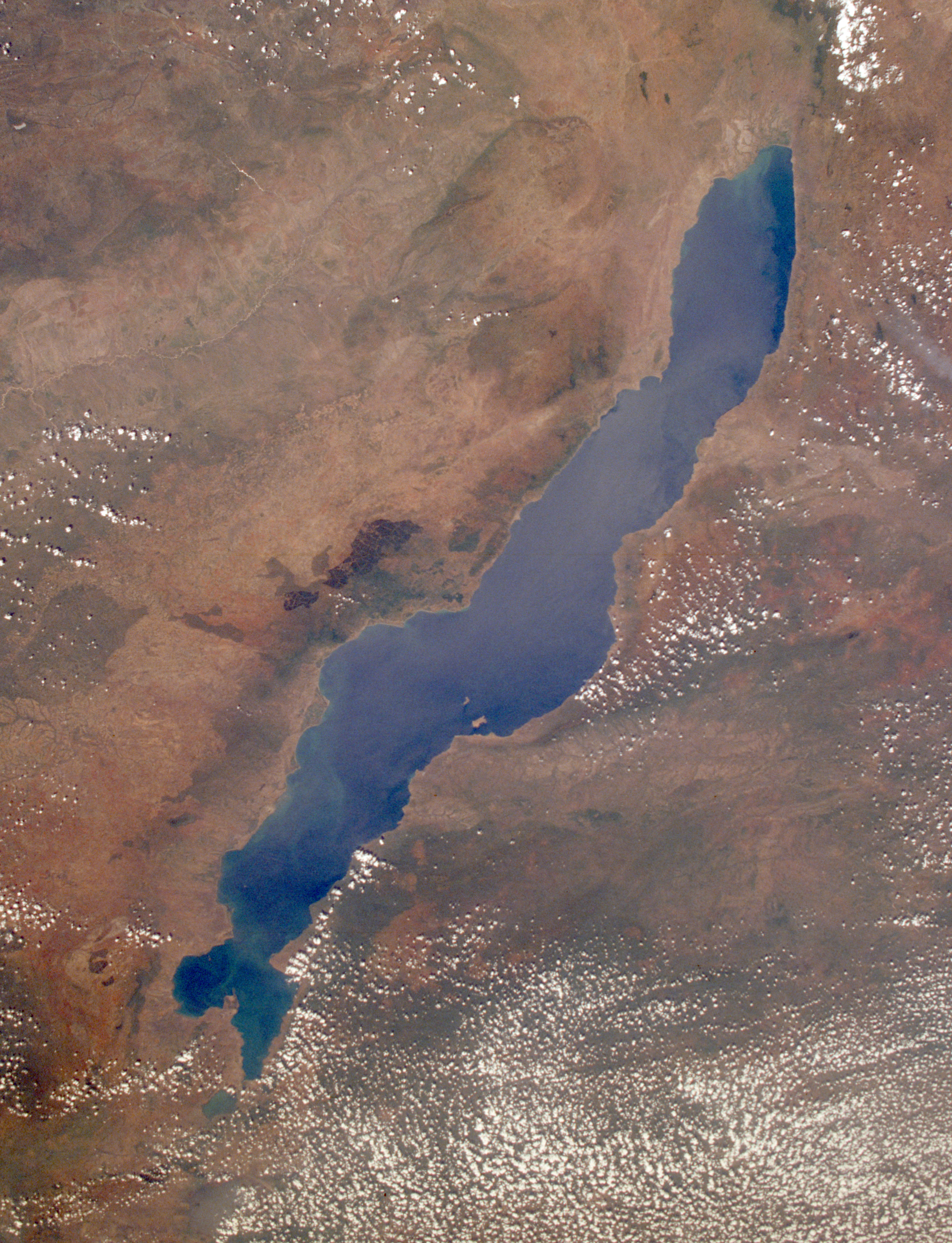
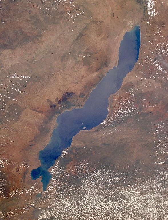
English: Leverkusen in Germany, photographed by astronauts aboard the Space Shuttle. Original image courtesy of the Image Analysis Laboratory, NASA Johnson Space Center (eol.jsc.nasa.gov). Image ID: STS061-75-48. Image cropped, sharpened and gamma-corrected.
|
| Data | Prise le 3 decembre de 1998, 09:49:31 UTC |
| Font | https://eol.jsc.nasa.gov/SearchPhotos/photo.pl?mission=STS061&roll=75&frame=48 |
| Autor | National Aeronautics and Space Administration (NASA) |
| Autras versions |

Aquest fitxer ha estat catalogat per Johnson Space Center dels Estats Units d'Amèrica per a l'Administració Nacional d'Aeronàutica i de l'Espai (NASA)en virtut identificat com a: ID del fitxer : STS061-75-48.Els ID dels fitxers i ID alternatius són traduïts de Photo ID .Aquesta etiqueta no indica l'estat dels drets d'autor de la imatge carregada. Cal un senyal de drets d'autor. Vegeu Commons:Sobre les llicències. Altres idiomes:
|
Publicat jos licéncia(s)
"The Gateway to Astronaut Photography of Earth". Image provenant du Laboratoire d'Analyse et d'Imagerie des Sciences, Centre Spatial Johnson de la NASA.
Source de la photo : STS061-75-48.
|
Registre original de càrregues
Uploaded to en wiki by User:Worldtraveller; moved here by User:Tintazul. Full original description follows.
Istoric del fichièr
Clicar sus una data e una ora per veire lo fichièr tal coma èra a aqueste moment
| Data e ora | Miniatura | Dimensions | Utilizaire | Comentari | |
|---|---|---|---|---|---|
| actual | 30 agost de 2019 a 19.17 | | 2 778×3 628 (3,24 Mo) | Ras67 | high resolution, cropped and rotated from NASA's original TIFF |
| 4 novembre de 2005 a 12.27 |  | 768×1 000 (271 Ko) | Tintazul | ''Uploaded to en wiki by User:Worldtraveller; moved here by User:Tintazul. Full original description follows.'' Lake Malawi in Africa, photographed by astronauts aboard the Space Shuttle. Original image courtesy of the Image Analysis Laboratory, |
Paginas que contenon lo fichièr
Las paginas çaijós compòrtan aqueste imatge :
- Lac Malawi
- Wikipèdia:Imatge del jorn/13 de julhet de 2010
- Wikipèdia:Imatge del jorn/13 de setembre de 2010
- Wikipèdia:Imatge del jorn/22 de julhet de 2010
- Wikipèdia:Imatge del jorn/31 de julhet de 2010
- Wikipèdia:Imatge del jorn/3 de novembre de 2011
- Wikipèdia:Imatge del jorn/3 de setembre de 2010
- Wikipèdia:Imatge del jorn/3 de setembre de 2011
- Wikipèdia:Imatge del jorn/julhet de 2010
- Wikipèdia:Imatge del jorn/novembre de 2011
- Wikipèdia:Imatge del jorn/setembre de 2010
- Wikipèdia:Imatge del jorn/setembre de 2011
Usatge global del fichièr
Los autres wikis seguents utilizan aqueste imatge :
- Utilizacion sus af.wikipedia.org
- Utilizacion sus als.wikipedia.org
- Utilizacion sus ar.wikipedia.org
- Utilizacion sus arz.wikipedia.org
- Utilizacion sus az.wikipedia.org
- Utilizacion sus ba.wikipedia.org
- Utilizacion sus be-tarask.wikipedia.org
- Utilizacion sus be.wikipedia.org
- Utilizacion sus bg.wikipedia.org
- Dimidiochromis compressiceps
- Labeotropheus trewavasae
- Labidochromis caeruleus
- Maylandia aurora
- Maylandia barlowi
- Maylandia benetos
- Maylandia callainos
- Maylandia chrysomallos
- Maylandia elegans
- Maylandia emmiltos
- Maylandia hajomaylandi
- Maylandia heteropicta
- Maylandia mbenjii
- Maylandia melabranchion
- Maylandia phaeos
- Maylandia pursa
- Maylandia pyrsonotos
- Maylandia thapsinogen
- Melanochromis parallelus
- Nimbochromis linni
- Nimbochromis polystigma
- Otopharynx brooksi
- Otopharynx lithobates
- Otopharynx tetrastigma
- Placidochromis electra
- Placidochromis johnstoni
- Placidochromis phenochilus
- Protomelas spilonotus
Veire l'utilizacion globala d'aqueste fichièr.