Fichièr:Hunter gatherer's camp at Irish National Heritage Park - geograph.org.uk - 1252699.jpg

Talha d'aquesta previsualizacion: 800 × 600 pixèls. Autras resolucions : 320 × 240 pixèls | 640 × 480 pixèls | 1 024 × 768 pixèls | 1 280 × 960 pixèls | 1 600 × 1 200 pixèls.
Fichièr d'origina (1 600 × 1 200 pixèl, talha del fichièr: 442 Ko, tipe MIME: image/jpeg)
| Aqueste fichièr proven de Wikimedia Commons?. Las informacions que lo concernisson son afichadas çaijós (procedura). |
Descripcion
| Descripcion |
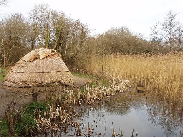
English: Hunter gatherer's camp at Irish National Heritage Park Exhibit showing how a 7000 B.C. campsite of Mesolithic period hunter gatherers would have looked. They were nomadic and built temporary houses. Wood, bone and flint were the materials of their tools. They fished using dugout canoes - there is one in the photo.
More photos in the park, see https://www.geograph.org.uk/gallery/irish_national_heritage_park_county_wexford_10033 . |
| Data | |
| Font | From geograph.org.uk |
| Autor | David Hawgood |
| Atribucion (imposé par la licence) | David Hawgood / Hunter gatherer's camp at Irish National Heritage Park / |
| Posició de la càmera | | Aquesta i altres imatges properes a: OpenStreetMap |
|---|
_heading:135.00&language=oc)
| Posició de l'objecte | | Aquesta i altres imatges properes a: OpenStreetMap |
|---|
_heading:135.00&language=oc)
Publicat jos licéncia(s)

|
Aquesta imatge prové de la col·lecció del projecte Geograph British Isles. Vegeu la pàgina d'aquesta fotografia al lloc web Geograph per a més informació del fotògraf. El titular dels drets d'autor d'aquesta imatge és David Hawgood i autoritza utilitzar-la sota la llicència Reconeixement-CompartirIgual 2.0 de Creative Commons.
|
Aqueste fichièr es jos licéncia Creative Commons licéncia generica atribucion-partiment a l'identic 2.0
Atribucion: David Hawgood
- Sètz liure :
- de partejar – de copiar, distribuir e transmetre aquesta òbra
- d'adaptar – d'adaptar aquesta òbra
- Jos las condicions seguentas :
- atribucion – Vos cal atribuir aquesta òbra amb lo biais especificat per l'autor o lo concedent (mas pas dins un sens que suggerís que vos apròvan o qu'apròvan l'utilizacion d'aquesta òbra).
- partiment a l'identic – Se modificatz, transformatz, o vos basatz sus aquesta òbra, vos cal distribuir l'òbra resultanta jos la meteissa licéncia o una licéncia similara a aquesta.
Istoric del fichièr
Clicar sus una data e una ora per veire lo fichièr tal coma èra a aqueste moment
| Data e ora | Miniatura | Dimensions | Utilizaire | Comentari | |
|---|---|---|---|---|---|
| actual | 7 setembre de 2017 a 21.41 | | 1 600×1 200 (442 Ko) | Geograph Update Bot | Higher-resolution version from Geograph. |
| 26 febrièr de 2011 a 20.15 |  | 640×480 (107 Ko) | GeographBot | == {{int:filedesc}} == {{Information |description={{en|1=Hunter gatherer's camp at Irish National Heritage Park Exhibit showing how a 7000 B.C. campsite of Mesolithic period hunter gatherers would have looked. They were nomadic and built temporary houses. |
Paginas que contenon lo fichièr
La pagina çaijós compòrta aqueste imatge :
Usatge global del fichièr
Los autres wikis seguents utilizan aqueste imatge :
- Utilizacion sus af.wikipedia.org
- Utilizacion sus ar.wikipedia.org
- Utilizacion sus azb.wikipedia.org
- Utilizacion sus bcl.wikipedia.org
- Utilizacion sus bs.wikipedia.org
- Utilizacion sus ca.wikipedia.org
- Utilizacion sus de.wikipedia.org
- Utilizacion sus en.wikipedia.org
- Utilizacion sus en.wikiquote.org
- Utilizacion sus fi.wikipedia.org
- Utilizacion sus fr.wikipedia.org
- Utilizacion sus ga.wikipedia.org
- Utilizacion sus lfn.wikipedia.org
- Utilizacion sus nl.wikipedia.org
- Utilizacion sus no.wikipedia.org
- Utilizacion sus ru.wikipedia.org
- Utilizacion sus sr.wikipedia.org
- Utilizacion sus szl.wikipedia.org
- Utilizacion sus ta.wikipedia.org