Fichièr:Guadeloupe map.png
Guadeloupe_map.png (313 × 336 pixèl, talha del fichièr: 11 Ko, tipe MIME: image/png)
Istoric del fichièr
Clicar sus una data e una ora per veire lo fichièr tal coma èra a aqueste moment
| Data e ora | Miniatura | Dimensions | Utilizaire | Comentari | |
|---|---|---|---|---|---|
| actual | 30 octobre de 2021 a 19.13 |  | 313×336 (11 Ko) | Auguel | Remove frame |
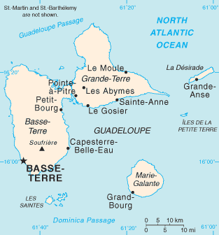
| 1 julhet de 2006 a 09.58 |  | 315×337 (10 Ko) | ArturM | Map of the French overseas département of Guadeloupe from the CIA World Factbook. http://www.cia.gov/cia/publications/factbook/geos/gp.html {{PD-USGov-CIA-WF}} |
Paginas que contenon lo fichièr
Las paginas çaijós compòrtan aqueste imatge :
Usatge global del fichièr
Los autres wikis seguents utilizan aqueste imatge :
- Utilizacion sus af.wikipedia.org
- Utilizacion sus ar.wikipedia.org
- Utilizacion sus azb.wikipedia.org
- Utilizacion sus az.wikipedia.org
- Utilizacion sus ban.wikipedia.org
- Utilizacion sus be-tarask.wikipedia.org
- Utilizacion sus bg.wikipedia.org
- Utilizacion sus bn.wikipedia.org
- Utilizacion sus br.wikipedia.org
- Utilizacion sus bs.wikipedia.org
- Utilizacion sus bug.wikipedia.org
- Utilizacion sus ca.wikipedia.org
- Utilizacion sus ceb.wikipedia.org
- Utilizacion sus cs.wikipedia.org
- Utilizacion sus cy.wikipedia.org
- Utilizacion sus da.wikipedia.org
- Utilizacion sus de.wikipedia.org
- Utilizacion sus dsb.wikipedia.org
- Utilizacion sus el.wikipedia.org
- Utilizacion sus en.wikipedia.org
- Guadeloupe
- Communes of the Guadeloupe department
- Grande-Terre
- La Désirade
- Marie-Galante
- List of airports in Guadeloupe
- Dominica Passage
- Guadeloupe Passage
- Portal:Caribbean/Selected geography article
- Portal:Caribbean/Selected geography article/13
- Petite Terre Islands
- Index of Guadeloupe-related articles
- Troude's expedition to the Caribbean
- 2009 French Caribbean general strikes
- Action of 22 January 1809
- Invasion of Guadeloupe (1810)
- Siege of Guadeloupe
- List of amphibians and reptiles of Guadeloupe
- Les Saintes Passage
- Marie-Galante Passage
- Module:Location map/data/Guadeloupe/doc
- Invasion of Guadeloupe (1815)
- Petite Terre Islands National Nature Reserve
Veire l'utilizacion globala d'aqueste fichièr.

