Fichièr:Ganymede terrain.jpg

Fichièr d'origina (1 764 × 809 pixèl, talha del fichièr: 729 Ko, tipe MIME: image/jpeg)
| Aqueste fichièr proven de Wikimedia Commons?. Las informacions que lo concernisson son afichadas çaijós (procedura). |
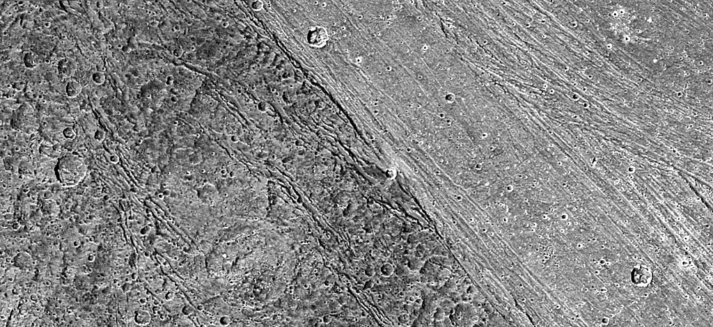
Terrain on Ganymede.
| Aquest fitxer és en el domini públic perquè ha estat creat per la NASA. L'avís legal de la NASA diu que «el material de la NASA no està protegit per copyright si no es diu el contrari». (NASA copyright policy page o JPL Image Use Policy). | ||
 |
Atenció:
|
| Descripcion |
English: Boundary between dark and light terrain on Ganymede. The photo is PIA02577 at the JPL Planetary Photojournal. It was taken by the Galileo spacecraft.
Original NASA caption: The ancient, dark terrain of Nicholson Regio (left) shows many large impact craters, and zones of fractures oriented generally parallel to the boundary between the dark and bright regions of Jupiter's moon Ganymede. In contrast, the bright terrain of Harpagia Sulcus (right) is less cratered and relatively smooth. The nature of the boundary between ancient, dark terrain and younger, bright terrain, the two principal terrain types on Ganymede, was explored by NASA's Galileo spacecraft on May 20, 2000. Subtle parallel ridges and grooves show that Harpagia Sulcus's land has been smoothed out over the years by tectonic processes. North is to the top of the picture. The Sun illuminates the surface from the left. The image, centered at ?14 degrees latitude and 319 degrees longitude, covers an area approximately 213 by 97 kilometers (132 by 60 miles.) The resolution is 121 meters (about 250 feet) per picture element. The images were taken on May 20, 2000, at a range of 11,800 kilometers (about 7,300 miles). |
| Font | http://photojournal.jpl.nasa.gov/catalog/PIA02577 |
| Autor | NASA/JPL/DLR |
Istoric del fichièr
Clicar sus una data e una ora per veire lo fichièr tal coma èra a aqueste moment
| Data e ora | Miniatura | Dimensions | Utilizaire | Comentari | |
|---|---|---|---|---|---|
| actual | 4 junh de 2005 a 20.58 | | 1 764×809 (729 Ko) | Dbenbenn | 1764x809 version, converted from TIF with quality 95% |
| 1 abril de 2005 a 01.35 |  | 1 476×677 (255 Ko) | Smartech~commonswiki | {{PD-USGov-NASA}} A picture of terrain on Ganymede, the satellite of Jupiter. From the english article about Ganymede. |
Paginas que contenon lo fichièr
La pagina çaijós compòrta aqueste imatge :
Usatge global del fichièr
Los autres wikis seguents utilizan aqueste imatge :
- Utilizacion sus af.wikipedia.org
- Utilizacion sus als.wikipedia.org
- Utilizacion sus ast.wikipedia.org
- Utilizacion sus ba.wikipedia.org
- Utilizacion sus bg.wikipedia.org
- Utilizacion sus br.wikipedia.org
- Utilizacion sus ca.wikipedia.org
- Utilizacion sus cs.wikipedia.org
- Utilizacion sus en.wikipedia.org
- Utilizacion sus en.wikiversity.org
- Utilizacion sus eo.wikipedia.org
- Utilizacion sus eu.wikipedia.org
- Utilizacion sus fr.wikipedia.org
- Utilizacion sus hy.wikipedia.org
- Utilizacion sus id.wikipedia.org
- Utilizacion sus ja.wikipedia.org
- Utilizacion sus ko.wikipedia.org
- Utilizacion sus nn.wikipedia.org
- Utilizacion sus no.wikipedia.org
- Utilizacion sus ro.wikipedia.org
- Utilizacion sus ru.wikipedia.org
- Utilizacion sus sk.wikipedia.org
- Utilizacion sus sr.wikipedia.org
- Utilizacion sus sv.wikipedia.org
- Utilizacion sus ta.wikipedia.org
- Utilizacion sus uk.wikipedia.org
- Utilizacion sus vi.wikipedia.org
- Utilizacion sus zh.wikipedia.org