Fichièr:Emi Koussi Volcano, Chad From ISS.JPG
Talha d'aquesta previsualizacion: 800 × 532 pixèls. Autras resolucions : 320 × 213 pixèls | 640 × 425 pixèls | 1 024 × 681 pixèls | 1 280 × 851 pixèls | 2 560 × 1 701 pixèls | 4 288 × 2 850 pixèls.
Fichièr d'origina (4 288 × 2 850 pixèl, talha del fichièr: 2,75 Mo, tipe MIME: image/jpeg)
| Aqueste fichièr proven de Wikimedia Commons?. Las informacions que lo concernisson son afichadas çaijós (procedura). |
Descripcion
| Descripcion |
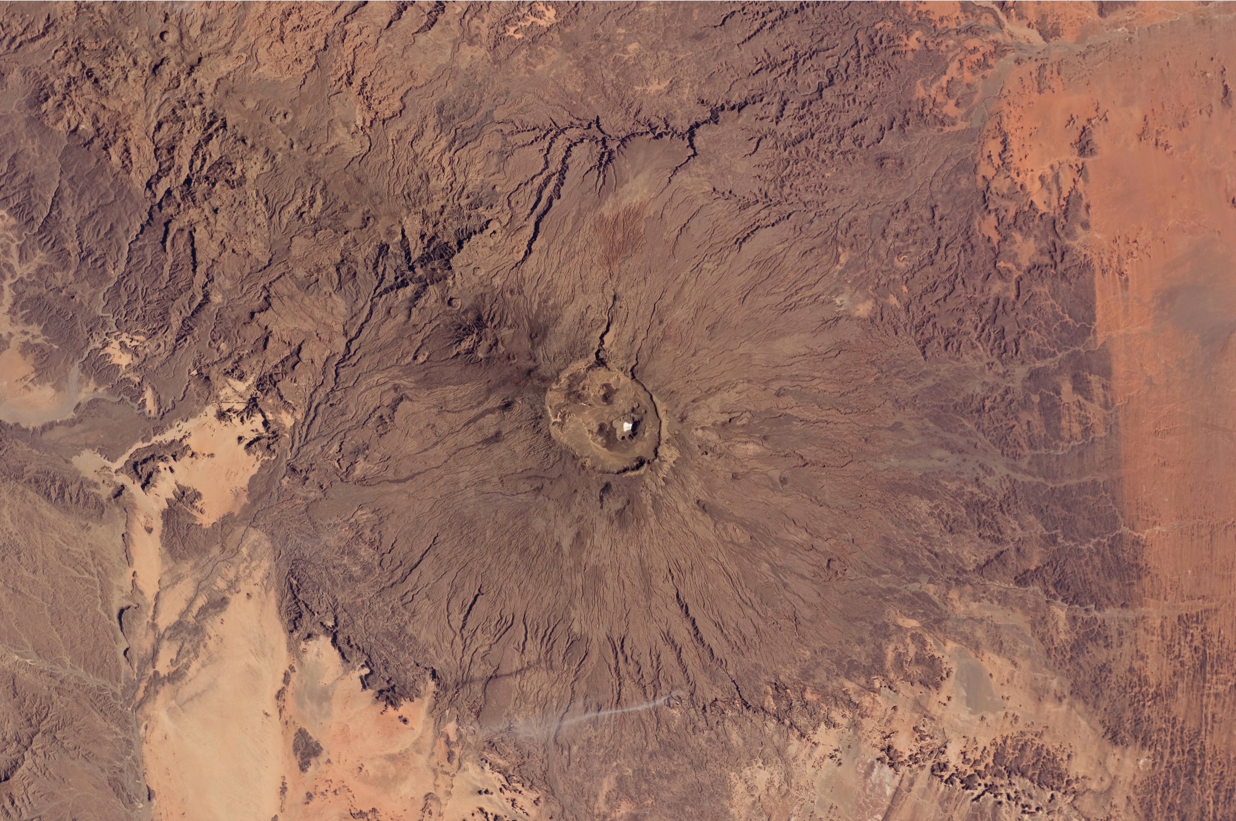
English: The broad Emi Koussi volcano is a shield volcano located in northern Chad, at the south-eastern end of the Tibesti Range. The dark volcanic rocks of the volcano provide a sharp contrast to the underlying tan and light brown sandstone exposed to the west, south, and east (image lower left, lower right, and upper right). This astronaut photograph highlights the entire volcanic structure. At 3,415 meters above sea level, Emi Koussi is the highest summit of Africa's Sahara region. The summit includes three calderas formed by powerful eruptions. Two older and overlapping calderas form a depression approximately 12 kilometres by 15 kilometres in area bounded by a distinct rim (image centre). The youngest and smallest caldera, Era Kohor, formed as a result of eruptive activity within the past 2 million years. |
| Data | |
| Font | NASA Earth Observatory |
| Autor | ISS Expedition 26 crew |
| Posició de la càmera | | Aquesta i altres imatges properes a: OpenStreetMap |
|---|
Aquest fitxer ha estat catalogat per Johnson Space Center dels Estats Units d'Amèrica per a l'Administració Nacional d'Aeronàutica i de l'Espai (NASA)en virtut identificat com a: ID del fitxer : ISS026-E-17074.Els ID dels fitxers i ID alternatius són traduïts de Photo ID .Aquesta etiqueta no indica l'estat dels drets d'autor de la imatge carregada. Cal un senyal de drets d'autor. Vegeu Commons:Sobre les llicències. Altres idiomes:
|
Image acquired with a Nikon D2Xs digital camera using a 70 mm lens, and is provided by the ISS Crew Earth Observations experiment and Image Science & Analysis Laboratory, Johnson Space Center.
Publicat jos licéncia(s)
"The Gateway to Astronaut Photography of Earth". Image provenant du Laboratoire d'Analyse et d'Imagerie des Sciences, Centre Spatial Johnson de la NASA.
Source de la photo : ISS026-E-17074.
|
| Anotacions | Aquesta imatge té anotacions: Vegeu-les a Commons |
Istoric del fichièr
Clicar sus una data e una ora per veire lo fichièr tal coma èra a aqueste moment
| Data e ora | Miniatura | Dimensions | Utilizaire | Comentari | |
|---|---|---|---|---|---|
| actual | 14 febrièr de 2011 a 12.50 | | 4 288×2 850 (2,75 Mo) | Originalwana | {{Information |Description ={{en|1=The broad Emi Koussi volcano is a shield volcano located in northern Chad, at the south-eastern end of the Tibesti Range. The dark volcanic rocks of the volcano provide a sharp contrast to the u |
Paginas que contenon lo fichièr
Las paginas çaijós compòrtan aqueste imatge :
Usatge global del fichièr
Los autres wikis seguents utilizan aqueste imatge :
- Utilizacion sus ar.wikipedia.org
- Utilizacion sus ca.wikipedia.org
- Utilizacion sus cs.wikipedia.org
- Utilizacion sus de.wikipedia.org
- Utilizacion sus en.wikipedia.org
- Utilizacion sus fa.wikipedia.org
- Utilizacion sus fi.wikipedia.org
- Utilizacion sus frr.wikipedia.org
- Utilizacion sus fr.wikipedia.org
- Utilizacion sus ja.wikipedia.org
- Utilizacion sus mk.wikipedia.org
- Utilizacion sus ru.wikipedia.org
- Utilizacion sus smn.wikipedia.org
- Utilizacion sus uk.wikipedia.org
- Utilizacion sus www.wikidata.org