Fichièr:Daedelus comparison, remote sensing in precision farming.jpg
Talha d'aquesta previsualizacion: 366 × 598 pixèls. Autras resolucions : 147 × 240 pixèls | 540 × 883 pixèls.
Fichièr d'origina (540 × 883 pixèl, talha del fichièr: 143 Ko, tipe MIME: image/jpeg)
| Aqueste fichièr proven de Wikimedia Commons?. Las informacions que lo concernisson son afichadas çaijós (procedura). |
| Descripcion |
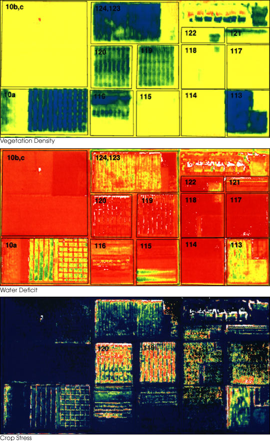
English: These three false-color images demonstrate some of the applications of remote sensing in precision farming. The goal of precision farming is to improve farmers’ profits and harvest yields while reducing the negative impacts of farming on the environment that come from over-application of chemicals. The images were acquired by the Daedalus sensor aboard a NASA aircraft flying over the Maricopa Agricultural Center in Arizona.
|
|||||
| Data | abans 30 genièr de 2001 | |||||
| Font | earthobservatory.nasa.gov (NASA Earth Observatory, Image of the Day 2001-01-30 "Precision Farming") | |||||
| Autor | Susan Moran, Landsat 7 Science Team and USDA Agricultural Research Service (U.S. Government work) | |||||
| Permission (Reütilizacion d'aqueste fichièr) |
|
|||||
| Autras versions |
.jpg) |

Istoric del fichièr
Clicar sus una data e una ora per veire lo fichièr tal coma èra a aqueste moment
| Data e ora | Miniatura | Dimensions | Utilizaire | Comentari | |
|---|---|---|---|---|---|
| actual | 28 junh de 2010 a 01.10 | | 540×883 (143 Ko) | Bdk | {{Information |Description={{en|These three false-color images demonstrate some of the applications of remote sensing in precision farming. The goal of precision farming is to improve farmers’ profits and harvest yields whi |
Paginas que contenon lo fichièr
Las paginas çaijós compòrtan aqueste imatge :
Usatge global del fichièr
Los autres wikis seguents utilizan aqueste imatge :
- Utilizacion sus ar.wikipedia.org
- Utilizacion sus en.wikipedia.org
- Utilizacion sus en.wikiversity.org
- Utilizacion sus eu.wikipedia.org
- Utilizacion sus fr.wikipedia.org
- Utilizacion sus id.wikipedia.org
- Utilizacion sus it.wikipedia.org
- Utilizacion sus ja.wikipedia.org
- Utilizacion sus ko.wikipedia.org
- Utilizacion sus ms.wikipedia.org
- Utilizacion sus ru.wikipedia.org
- Utilizacion sus ta.wikipedia.org
- Utilizacion sus tr.wikipedia.org
- Utilizacion sus uk.wikipedia.org
- Utilizacion sus www.wikidata.org