Fichièr:Carte Lewis and Clark Expedition.png
Talha d'aquesta previsualizacion: 800 × 520 pixèls. Autras resolucions : 320 × 208 pixèls | 640 × 416 pixèls | 1 024 × 665 pixèls | 1 513 × 983 pixèls.
Fichièr d'origina (1 513 × 983 pixèl, talha del fichièr: 84 Ko, tipe MIME: image/png)
| Aqueste fichièr proven de Wikimedia Commons?. Las informacions que lo concernisson son afichadas çaijós (procedura). |

|
Aquesta imatge (de tipus historical map) s'hauria de tornar a crear utilitzant gràfics vectorials com ara un fitxer SVG. Això té diversos avantatges; en trobareu més informació a Commons:Media for cleanup. Si ja disposeu d'una versió d'aquesta imatge en format SVG, us preguem que la pengeu; després, reemplaceu aquesta plantilla amb la plantilla {{Vector version available|nom nou de la imatge.svg}} en aquesta imatge.
|
Descripcion
| Descripcion |
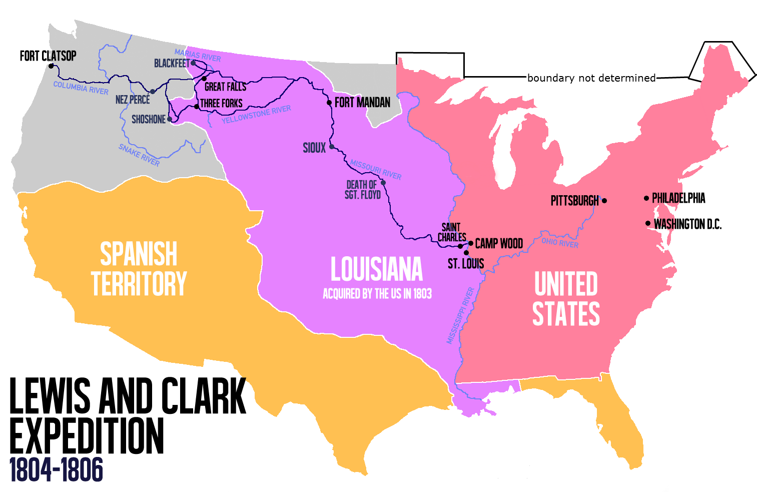
English: Route of the Lewis and Clark Expedition |
| Data | |
| Font |
Trabalh personal, Ce fichier est dérivé de : Carte Lewis-Clark Expedition-en.png |
| Autor | Victor van Werkhooven |
| Autras versions |
 |
Publicat jos licéncia(s)
| Jo, el titular del copyright d'aquesta obra, l'allibero al domini públic. Això s'aplica a tot el món. En alguns països això pot no ser legalment possible, en tal cas: Jo faig concessió a tothom del dret d'usar aquesta obra per a qualsevol propòsit, sense cap condició llevat d'aquelles requerides per la llei. |
Istoric del fichièr
Clicar sus una data e una ora per veire lo fichièr tal coma èra a aqueste moment
| Data e ora | Miniatura | Dimensions | Utilizaire | Comentari | |
|---|---|---|---|---|---|
| actual | 13 junh de 2014 a 14.21 | | 1 513×983 (84 Ko) | Nwbeeson | Reverted to version as of 14:18, 13 June 2014 |
| 13 junh de 2014 a 14.20 |  | 1 513×983 (84 Ko) | Nwbeeson | Corrected boundary of the United States. The original left out Maine, Michigan, Wisconsin, and part of Minnesota, none of which were states, but all of which were definitely part of the territory of the United States. | |
| 13 junh de 2014 a 14.18 |  | 1 513×983 (84 Ko) | Nwbeeson | Corrected boundary of the United States. The original left out Maine, Michigan, Wisconsin, and part of Minnesota, none of which were states, but all of which were definitely part of the territory of the United States. | |
| 22 mai de 2014 a 15.17 |  | 1 513×983 (134 Ko) | Luctor | User created page with UploadWizard |
Paginas que contenon lo fichièr
La pagina çaijós compòrta aqueste imatge :
Usatge global del fichièr
Los autres wikis seguents utilizan aqueste imatge :
- Utilizacion sus ast.wikipedia.org
- Utilizacion sus bn.wikipedia.org
- Utilizacion sus de.wikipedia.org
- Utilizacion sus en.wikipedia.org
- Utilizacion sus es.wikipedia.org
- Utilizacion sus et.wikipedia.org
- Utilizacion sus eu.wikipedia.org
- Utilizacion sus fa.wikipedia.org
- Utilizacion sus gl.wikipedia.org
- Utilizacion sus hu.wikipedia.org
- Utilizacion sus it.wikipedia.org
- Utilizacion sus ko.wikipedia.org
- Utilizacion sus ms.wikipedia.org
- Utilizacion sus nl.wikipedia.org
- Utilizacion sus no.wikipedia.org
- Utilizacion sus pl.wikipedia.org
- Utilizacion sus sr.wikipedia.org
- Utilizacion sus tr.wikipedia.org
- Utilizacion sus www.wikidata.org
- Utilizacion sus zh.wikipedia.org