Fichièr:PonticKingdom.png

Talha d'aquesta previsualizacion: 718 × 600 pixèls. Autras resolucions : 287 × 240 pixèls | 575 × 480 pixèls | 919 × 768 pixèls | 1 226 × 1 024 pixèls | 1 551 × 1 296 pixèls.
Fichièr d'origina (1 551 × 1 296 pixèl, talha del fichièr: 265 Ko, tipe MIME: image/png)
| Aqueste fichièr proven de Wikimedia Commons?. Las informacions que lo concernisson son afichadas çaijós (procedura). |

|
Aquesta imatge (de tipus historical map) s'hauria de tornar a crear utilitzant gràfics vectorials com ara un fitxer SVG. Això té diversos avantatges; en trobareu més informació a Commons:Media for cleanup. Si ja disposeu d'una versió d'aquesta imatge en format SVG, us preguem que la pengeu; després, reemplaceu aquesta plantilla amb la plantilla {{Vector version available|nom nou de la imatge.svg}} en aquesta imatge.
|
| Descripcion |
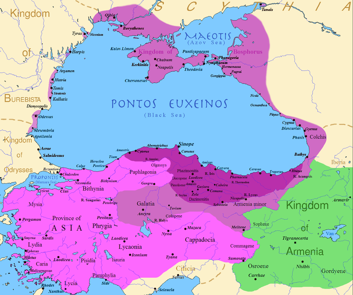
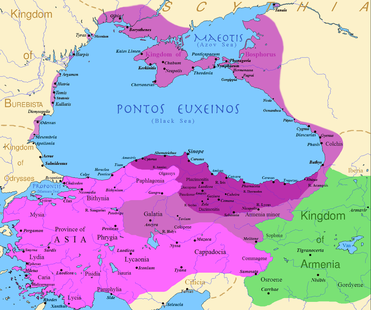
English: Map of the Kingdom of Pontus, Before the reign of Mithridates VI (darkest purple), after his conquests (purple), and his conquests in the first Mithridatic wars (pink); little adds (ancient shorelines & some greek colonies under Mithridate's rule) according with V. Yanko-Hombach, A.S. Gilbert, N. Panin, P. M. Dolukhanov: The Black Sea Flood Question: Changes in Coastline, Climate, and Human Settlement, Springer, Netherlands, 2007, and with Appianus, Plutarchus & Strabo. |
| Data | |
| Font | I (Javierfv1212 (talk)) created this work entirely by myself. Sources, Cambridge Ancient history volume 9, Penguin atlas of Greek history and the Foreign Policy of Mithridates VI Eupator. |
| Autor | Javierfv1212 (talk) |
Publicat jos licéncia(s)
| S'ha alliberat aquesta obra al domini públic pel seu autor Javierfv1212 de Wikipèdia en anglés. Això s'aplica a tot el món. En alguns països això pot no ser legalment possible, en tal cas: Javierfv1212 concedeix a tothom el dret d'usar aquesta obra per a qualsevol propòsit, sense cap condició llevat d'aquelles requerides per la llei. |
Registre original de càrregues
Transferred from en.wikipedia to Commons by Falcorian using CommonsHelper.
The original description page was here. All following user names refer to en.wikipedia.
- 2009-07-19 23:42 Javierfv1212 1551×1296× (205182 bytes) {{Information |Description = Map of the Kingdom of Pontus, Before the reign of mithridates VI (darkest purple), after his conquests (purple), and his conquests in the first Mithridatic wars (pink). |Source = I (~~~) created this work entirel
Istoric del fichièr
Clicar sus una data e una ora per veire lo fichièr tal coma èra a aqueste moment
| Data e ora | Miniatura | Dimensions | Utilizaire | Comentari | |
|---|---|---|---|---|---|
| actual | 9 decembre de 2017 a 02.00 | | 1 551×1 296 (265 Ko) | SteinsplitterBot | Bot: Image rotated by 90° |
| 9 decembre de 2017 a 00.00 |  | 1 296×1 551 (316 Ko) | SteinsplitterBot | Bot: Image rotated by 270° | |
| 22 setembre de 2016 a 17.54 |  | 1 551×1 296 (265 Ko) | Hohum | Lighten water area | |
| 9 agost de 2016 a 11.21 |  | 1 551×1 296 (260 Ko) | MAXHO | Details : more cities & shoreline of this time | |
| 1 octobre de 2015 a 20.57 |  | 1 551×1 296 (249 Ko) | Spiridon Ion Cepleanu | Cosmetic again | |
| 30 setembre de 2015 a 12.55 |  | 1 551×1 296 (247 Ko) | Spiridon Ion Cepleanu | Cosmetic colours & background names | |
| 7 abril de 2014 a 14.21 |  | 1 551×1 296 (225 Ko) | Spiridon Ion Cepleanu | Little changes (ancient shoreline & some greek colonies under Pontic rule) according with V. Yanko-Hombach, A.S. Gilbert, N. Panin, P. M. Dolukhanov: ''The Black Sea Flood Question: Changes in Coastline, Climate, and Human Settlement'', Springer, Nethe... | |
| 20 julhet de 2009 a 04.14 |  | 1 551×1 296 (200 Ko) | File Upload Bot (Magnus Manske) | {{BotMoveToCommons|en.wikipedia|year={{subst:CURRENTYEAR}}|month={{subst:CURRENTMONTHNAME}}|day={{subst:CURRENTDAY}}}} {{Information |Description={{en|Map of the Kingdom of Pontus, Before the reign of mithridates VI (darkest purple), after his conquests |
Paginas que contenon lo fichièr
La pagina çaijós compòrta aqueste imatge :
Usatge global del fichièr
Los autres wikis seguents utilizan aqueste imatge :
- Utilizacion sus ar.wikipedia.org
- Utilizacion sus ast.wikipedia.org
- Utilizacion sus azb.wikipedia.org
- Utilizacion sus az.wikipedia.org
- Utilizacion sus bg.wikipedia.org
- Utilizacion sus br.wikipedia.org
- Utilizacion sus ca.wikipedia.org
- Utilizacion sus cs.wikipedia.org
- Utilizacion sus da.wikipedia.org
- Utilizacion sus de.wikipedia.org
- Utilizacion sus el.wikipedia.org
- Utilizacion sus en.wikipedia.org
- Utilizacion sus es.wikipedia.org
- Utilizacion sus et.wikipedia.org
- Utilizacion sus eu.wikipedia.org
- Utilizacion sus fa.wikipedia.org
- Utilizacion sus fr.wikipedia.org
Veire l'utilizacion globala d'aqueste fichièr.