Fichièr:L'île de la Réunion vue par le satellite Sentinel-2 (cropped).jpg

Fichièr d'origina (5 000 × 4 232 pixèl, talha del fichièr: 18,68 Mo, tipe MIME: image/jpeg)
| Aqueste fichièr proven de Wikimedia Commons?. Las informacions que lo concernisson son afichadas çaijós (procedura). |
Descripcion
| Descripcion |
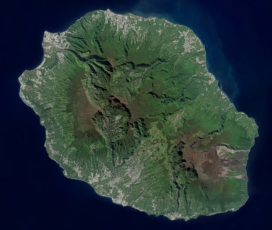
Français : L'île de la Réunion vue par le satellite Sentinel-2
English: Réunion island (Indian Ocean) photographed by Sentinel-2 satellite. |
| Data | |
| Font | https://phototheque.cnes.fr/cnes/media/68926 |
| Autor | European Space Agency / CNES |
| Autras versions |

.jpg?uselang=oc)
| Posició de la càmera | | Aquesta i altres imatges properes a: OpenStreetMap |
|---|
.jpg¶ms=-21.134472_N_0055.247103_E_globe:Earth_type:camera__&language=oc)
Publicat jos licéncia(s)

|
This image contains data from a satellite in the Copernicus Programme, such as Sentinel-1, Sentinel-2 or Sentinel-3. Attribution is required when using this image.
Atribucion: Contains modified Copernicus Sentinel data 2021
The use of Copernicus Sentinel Data is regulated under EU law (Commission Delegated Regulation (EU) No 1159/2013 and Regulation (EU) No 377/2014). Relevant excerpts:
Free access shall be given to GMES dedicated data [...] made available through GMES dissemination platforms [...].
Access to GMES dedicated data [...] shall be given for the purpose of the following use in so far as it is lawful:
GMES dedicated data [...] may be used worldwide without limitations in time.
GMES dedicated data and GMES service information are provided to users without any express or implied warranty, including as regards quality and suitability for any purpose. |

|
Aquesta imatge ha estat avaluada segons els criteris d'imatge valuosa i ha estat considerada la imatge més valuosa que hi ha a Commons referida a l'àmbit: Réunion island, France - satellite view.. Pots veure'n la nominació a Commons:Valued image candidates/L'île de la Réunion vue par le satellite Sentinel-2 (cropped).jpg. |
.jpg)
Istoric del fichièr
Clicar sus una data e una ora per veire lo fichièr tal coma èra a aqueste moment
| Data e ora | Miniatura | Dimensions | Utilizaire | Comentari | |
|---|---|---|---|---|---|
| actual | 6 setembre de 2022 a 14.12 | | 5 000×4 232 (18,68 Mo) | Skimel | File:L'île de la Réunion vue par le satellite Sentinel-2.jpg cropped 15 % vertically using CropTool with precise mode. |
Paginas que contenon lo fichièr
La pagina çaijós compòrta aqueste imatge :
Usatge global del fichièr
Los autres wikis seguents utilizan aqueste imatge :
- Utilizacion sus ar.wikipedia.org
- Utilizacion sus arz.wikipedia.org
- Utilizacion sus ast.wikipedia.org
- Utilizacion sus az.wikipedia.org
- Utilizacion sus ca.wikipedia.org
- Utilizacion sus ce.wikipedia.org
- Utilizacion sus cy.wikipedia.org
- Utilizacion sus diq.wikipedia.org
- Utilizacion sus es.wikipedia.org
- Utilizacion sus es.wikivoyage.org
- Utilizacion sus fr.wikinews.org
- Utilizacion sus fr.wikivoyage.org
- Utilizacion sus ga.wikipedia.org
- Utilizacion sus gl.wikipedia.org
- Utilizacion sus ht.wikipedia.org
- Utilizacion sus hy.wikipedia.org
- Utilizacion sus ia.wikipedia.org
- Utilizacion sus ig.wikipedia.org
- Utilizacion sus ku.wikipedia.org
- Utilizacion sus no.wikipedia.org
- Utilizacion sus pl.wikipedia.org
- Utilizacion sus ps.wikipedia.org
- Utilizacion sus tl.wikipedia.org
- Utilizacion sus vec.wikipedia.org
- Utilizacion sus vi.wikipedia.org
- Utilizacion sus www.wikidata.org
.jpg)