Fichièr:ISS021-E-15710 Pearl Harbor, Hawaii.jpg

Fichièr d'origina (4 288 × 2 848 pixèl, talha del fichièr: 11,07 Mo, tipe MIME: image/jpeg)
| Aqueste fichièr proven de Wikimedia Commons?. Las informacions que lo concernisson son afichadas çaijós (procedura). |
Descripcion
| Descripcion |
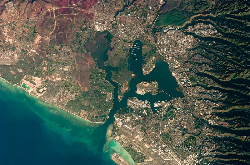
English: This detailed astronaut photograph illustrates the southern coastline of the Hawaiian island Oahu, including Pearl Harbor. On December 7, 1941—68 years ago—a surprise attack by the Japanese Navy on Pearl Harbor and other targets on the island of Oahu precipitated the entry of the United States into World War II. Today, Pearl Harbor is still in use as a major United States Navy installation, and along with Honolulu, it is one of the most heavily developed parts of the island.
A comparison between this image and a 2003 astronaut photograph of Pearl Harbor suggests that little observable land use or land cover change has occurred in the area over the past six years. The most significant difference is the presence of more naval vessels in the Reserve Fleet anchorage in Middle Loch (image center). The urban areas of Waipahu, Pearl City, and Aliamanu border the harbor to the northwest, north, and east. The built-up areas, recognizable by linear streets and white rooftops, contrast sharply with the reddish volcanic soils and green vegetation on the surrounding hills.
|
||||||||||||||||||||||||||||||||||||||||||||||||||
| Data | |||||||||||||||||||||||||||||||||||||||||||||||||||
| Font | http://eol.jsc.nasa.gov/scripts/sseop/photo.pl?mission=ISS021&roll=E&frame=15710 | ||||||||||||||||||||||||||||||||||||||||||||||||||
| Autor |
|
||||||||||||||||||||||||||||||||||||||||||||||||||
| Autras versions |
|
||||||||||||||||||||||||||||||||||||||||||||||||||

| Posició de la càmera | | Aquesta i altres imatges properes a: OpenStreetMap |
|---|
| Posició de l'objecte | | Aquesta i altres imatges properes a: OpenStreetMap |
|---|
Aquest fitxer ha estat catalogat per Johnson Space Center dels Estats Units d'Amèrica per a l'Administració Nacional d'Aeronàutica i de l'Espai (NASA)en virtut identificat com a: ID del fitxer : ISS021-E-15710.Els ID dels fitxers i ID alternatius són traduïts de Photo ID .Aquesta etiqueta no indica l'estat dels drets d'autor de la imatge carregada. Cal un senyal de drets d'autor. Vegeu Commons:Sobre les llicències. Altres idiomes:
|
Publicat jos licéncia(s)
| Aquest fitxer és en el domini públic perquè ha estat creat per la NASA. L'avís legal de la NASA diu que «el material de la NASA no està protegit per copyright si no es diu el contrari». (NASA copyright policy page o JPL Image Use Policy). | ||
 |
Atenció:
|
| Annotations | This image is annotated: View the annotations at Commons |
Istoric del fichièr
Clicar sus una data e una ora per veire lo fichièr tal coma èra a aqueste moment
| Data e ora | Miniatura | Dimensions | Utilizaire | Comentari | |
|---|---|---|---|---|---|
| actual | 22 març de 2013 a 17.34 | | 4 288×2 848 (11,07 Mo) | Julian Herzog | User created page with UploadWizard |
Paginas que contenon lo fichièr
La pagina çaijós compòrta aqueste imatge :
Usatge global del fichièr
Los autres wikis seguents utilizan aqueste imatge :
- Utilizacion sus bn.wikipedia.org
- Utilizacion sus ca.wikipedia.org
- Utilizacion sus de.wikipedia.org
- Utilizacion sus en.wikipedia.org
- Utilizacion sus en.wikiversity.org
- Utilizacion sus es.wikipedia.org
- Utilizacion sus fr.wikipedia.org
- Utilizacion sus fy.wikipedia.org
- Utilizacion sus gn.wikipedia.org
- Utilizacion sus pt.wikipedia.org
- Utilizacion sus zh.wikipedia.org